History Timeline
The static timeline map is intended to show the overall growth of the community and its amenities through the decades starting in 1990. While some villages may have been plated and recorded with the county prior to 1990, the map below depicts what decade building (development and/or spot lot) and amenity creation occurred from approximately 1990 onward. Please note, several villages and amenities were primarily established by 1990 and are included on the “1990-1999” map.
To view plats, historic landscape, and roadway developments through the years, Members can utilize timeline features within Frederick County’s Geographic Information System (GIS). Google Earth Pro is another visual resource for historic visuals.
In addition, Members can learn more about the history of the community and founder, Bill Brosius, through reading Discovering Eaglehead: The Man, The Vision, & The History of Lake Linganore, by Charissa Roberson. Each book is $10, and proceeds from the book benefit the Lake Linganore Scholarship Fund. Email communications@lakelinganore.org or phone 301-831-6400 x 115.
-
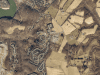
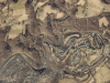
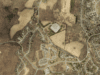
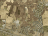
Historic Master Plan of Lake Linganore
https://maps.lakelinganore.org/wp-content/uploads/2020/03/2-1.jpg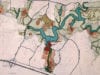
-
Bill Brosius with original Lake Linganore Plans
https://maps.lakelinganore.org/wp-content/uploads/2020/03/1-1.jpg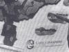
-
Bill Brosius preliminary logo sketches on napkins (photo from the Brosius Family)
https://maps.lakelinganore.org/wp-content/uploads/2020/03/30.jpg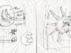
-
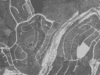
Lake Linganore prior to filling
https://maps.lakelinganore.org/wp-content/uploads/2020/03/20.jpgThe blue tree designated the depth of the future Lake Linganore.
-
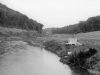
1968 Linganore Creek (photo from the Brosius Family)
https://maps.lakelinganore.org/wp-content/uploads/slideshow-gallery/1968-Linganore-Creek-Upstream-of-Dam-Under-Construction-Possible-City-Water-Intake-In-Foreground.jpgThe photo is the view upstream of dam under construction (possible City water intake in foreground)
-
Lake filling
https://maps.lakelinganore.org/wp-content/uploads/2020/03/19.jpg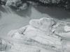
-
Stocking the Lake with fish
https://maps.lakelinganore.org/wp-content/uploads/2020/03/22.jpg
-
Sailing on Lake Linganore
https://maps.lakelinganore.org/wp-content/uploads/2020/03/21.jpg
-
Lake Anita Louise circa 1972 (photo from the Brosius Family)
https://maps.lakelinganore.org/wp-content/uploads/slideshow-gallery/Lake-Anita-Louise-circa-1972-photo-from-the-Brosius-Family.jpgConstruction of Lake Anita Louise was to be the first of two lakes in Pinehurst. Farm pond is in foreground. Farm buildings and barns on both sides were to be renovated for Pinehurst Village Center.
-
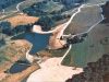
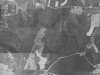
Aerial view of Lake Linganore in 1968 before the dam (picture from the Brosius Family)
https://maps.lakelinganore.org/wp-content/uploads/2020/03/23.jpg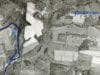
-
Lake Linganore entrance circa 1972 (picture from Brosius Family)
https://maps.lakelinganore.org/wp-content/uploads/2020/03/26.jpg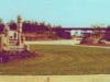
-
Audubon Terrace in October 1986
https://maps.lakelinganore.org/wp-content/uploads/2020/03/29.jpg
-
1980s picture of a Coldstream home
https://maps.lakelinganore.org/wp-content/uploads/2020/03/31.jpg
-
View from Coldstream Drive in October 1985
https://maps.lakelinganore.org/wp-content/uploads/2020/03/33.jpg
-
View from Coldstream Drive in October 1985
https://maps.lakelinganore.org/wp-content/uploads/2020/03/34.jpg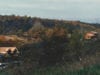
-
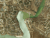
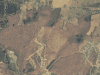
Aerial view of Coldstream Beach taken in the late 1980's
https://maps.lakelinganore.org/wp-content/uploads/2020/03/4-1.jpg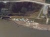
-
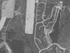
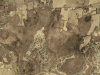
Aerial view of Coldstream Beach taken in the late 1980's
https://maps.lakelinganore.org/wp-content/uploads/2020/03/5.jpg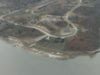
-
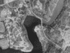
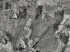
Aerial view of Nightingale and Coldstream Villages prior to most home building
https://maps.lakelinganore.org/wp-content/uploads/2020/03/6.jpg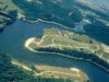
-
Coldstream Beach view
https://maps.lakelinganore.org/wp-content/uploads/2020/03/18.jpg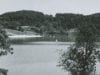
-
Esplanade sewer drawing
https://maps.lakelinganore.org/wp-content/uploads/2020/03/16.jpg
-
Esplanade building
https://maps.lakelinganore.org/wp-content/uploads/2020/03/13.jpg
-
Esplanade building
https://maps.lakelinganore.org/wp-content/uploads/2020/03/14.jpg
-
Esplanade building
https://maps.lakelinganore.org/wp-content/uploads/2020/03/15.jpg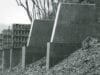
-
Esplanade building
https://maps.lakelinganore.org/wp-content/uploads/2020/03/17.jpg
-
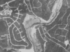
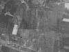
Aerial view of the Esplanade and Nightingale and Coldstream Villages in 1972 (picture from the Brosius Family)
https://maps.lakelinganore.org/wp-content/uploads/2020/03/7.jpg
-
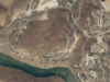
Historic image of Brosius Dam
https://maps.lakelinganore.org/wp-content/uploads/2020/03/12.jpg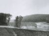
-
Bill and Lou Brosius at the Brosius Dam dedication
https://maps.lakelinganore.org/wp-content/uploads/2020/03/10.jpg
-
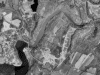
Indian Caves Park Project circa 1985
https://maps.lakelinganore.org/wp-content/uploads/2020/03/32.jpg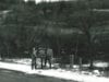
-
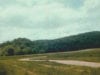
Historic MD 144 entrance
https://maps.lakelinganore.org/wp-content/uploads/2020/03/27.jpgCherry trees lined the original community entrance (located where the current traffic circle is on Route 144).

-
Aspen home being built in October 1986
https://maps.lakelinganore.org/wp-content/uploads/2020/03/28.jpg
-
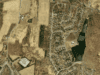
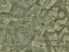
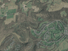
Aspen
https://maps.lakelinganore.org/wp-content/uploads/slideshow-gallery/Aspen-scaled.jpgThe following screenshots are from Frederick County's Geographic Information Systems (GIS) Aerial Report from 1973 to 2017.

-
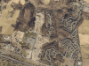
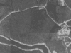
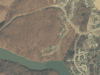
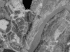
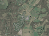
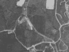
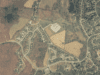
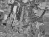
Aspen 1973
https://maps.lakelinganore.org/wp-content/uploads/2020/03/1973.pngScreenshots are from Frederick County's Geographic Information Systems (GIS) Aerial Report.
-
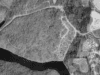
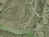
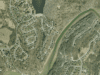
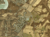
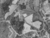
Aspen 1988
https://maps.lakelinganore.org/wp-content/uploads/2020/03/1998.pngScreenshots are from Frederick County's Geographic Information Systems (GIS) Aerial Report.
-
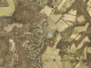
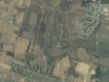
Aspen 1993
https://maps.lakelinganore.org/wp-content/uploads/2020/04/Aspen-1993.pngScreenshots are from Frederick County's Geographic Information Systems (GIS) Aerial Report.

-
Aspen 2000
https://maps.lakelinganore.org/wp-content/uploads/2020/03/2000.pngScreenshots are from Frederick County's Geographic Information Systems (GIS) Aerial Report.
-
Aspen 2005
https://maps.lakelinganore.org/wp-content/uploads/2020/03/2005.pngScreenshots are from Frederick County's Geographic Information Systems (GIS) Aerial Report.
-
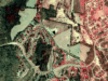
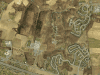
Aspen 2011
https://maps.lakelinganore.org/wp-content/uploads/2020/03/2011.pngScreenshots are from Frederick County's Geographic Information Systems (GIS) Aerial Report.

-
Aspen 2014
https://maps.lakelinganore.org/wp-content/uploads/2020/03/2014.pngScreenshots are from Frederick County's Geographic Information Systems (GIS) Aerial Report.

-
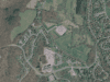
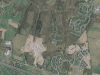
Aspen 2017
https://maps.lakelinganore.org/wp-content/uploads/2020/03/2017.pngScreenshots are from Frederick County's Geographic Information Systems (GIS) Aerial Report.
-
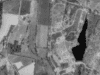
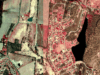
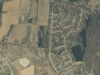
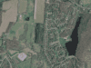
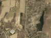
Pinehurst and Lake Anita Louise
https://maps.lakelinganore.org/wp-content/uploads/slideshow-gallery/Pinehurst-and-LAL-scaled.jpgThe following screenshots are from Frederick County's Geographic Information Systems (GIS) Aerial Report from 1973 to 2017.

-
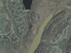
Pinehurst and Lake Anita Louise 1973
https://maps.lakelinganore.org/wp-content/uploads/2020/04/Pinehurst-and-Lake-Anita-Louise-1973.pngScreenshots are from Frederick County's Geographic Information Systems (GIS) Aerial Report.

-
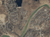
Pinehurst and Lake Anita Louise 1988
https://maps.lakelinganore.org/wp-content/uploads/2020/04/Pinehurst-and-Lake-Anita-Louise-1988.pngScreenshots are from Frederick County's Geographic Information Systems (GIS) Aerial Report.
-
Pinehurst and Lake Anita Louise 1993
https://maps.lakelinganore.org/wp-content/uploads/2020/04/Pinehurst-and-Lake-Anita-Louise-1993.pngScreenshots are from Frederick County's Geographic Information Systems (GIS) Aerial Report.
-
Pinehurst and Lake Anita Louise 2000
https://maps.lakelinganore.org/wp-content/uploads/2020/04/Pinehurst-and-Lake-Anita-Louise-2000.pngScreenshots are from Frederick County's Geographic Information Systems (GIS) Aerial Report.
-
Pinehurst and Lake Anita Louise 2005
https://maps.lakelinganore.org/wp-content/uploads/2020/04/Pinehurst-and-Lake-Anita-Louise-2005.pngScreenshots are from Frederick County's Geographic Information Systems (GIS) Aerial Report.
-
Pinehurst and Lake Anita Louise 2007
https://maps.lakelinganore.org/wp-content/uploads/2020/04/Pinehurst-and-Lake-Anita-Louise-2007.pngScreenshots are from Frederick County's Geographic Information Systems (GIS) Aerial Report.
-
Pinehurst and Lake Anita Louise 2011
https://maps.lakelinganore.org/wp-content/uploads/2020/04/Pinehurst-and-Lake-Anita-Louise-2011.pngScreenshots are from Frederick County's Geographic Information Systems (GIS) Aerial Report.
-
Pinehurst and Lake Anita Louise 2014
https://maps.lakelinganore.org/wp-content/uploads/2020/04/Pinehurst-and-Lake-Anita-Louise-2014.pngScreenshots are from Frederick County's Geographic Information Systems (GIS) Aerial Report.
-
Pinehurst and Lake Anita Louise 2017
https://maps.lakelinganore.org/wp-content/uploads/2020/04/Pinehurst-and-Lake-Anita-Louise-2017.pngScreenshots are from Frederick County's Geographic Information Systems (GIS) Aerial Report.
-
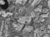
Balmoral
https://maps.lakelinganore.org/wp-content/uploads/slideshow-gallery/Balmoral-scaled.jpgThe following screenshots are from Frederick County's Geographic Information Systems (GIS) Aerial Report from 1973 to 2017.

-
Balmoral 1973
https://maps.lakelinganore.org/wp-content/uploads/2020/03/1973-2.pngScreenshots are from Frederick County's Geographic Information Systems (GIS) Aerial Report.
-
Balmoral 1988
https://maps.lakelinganore.org/wp-content/uploads/2020/03/1988-1.pngScreenshots are from Frederick County's Geographic Information Systems (GIS) Aerial Report.
-
Balmoral 1993
https://maps.lakelinganore.org/wp-content/uploads/2020/03/1993-2.pngScreenshots are from Frederick County's Geographic Information Systems (GIS) Aerial Report.

-
Balmoral 2000
https://maps.lakelinganore.org/wp-content/uploads/2020/03/2000-2.pngScreenshots are from Frederick County's Geographic Information Systems (GIS) Aerial Report.

-
Balmoral 2005
https://maps.lakelinganore.org/wp-content/uploads/2020/03/2005-2.pngScreenshots are from Frederick County's Geographic Information Systems (GIS) Aerial Report.
-
Balmoral 2007
https://maps.lakelinganore.org/wp-content/uploads/2020/03/2007-2.pngScreenshots are from Frederick County's Geographic Information Systems (GIS) Aerial Report.
-
Balmoral 2011
https://maps.lakelinganore.org/wp-content/uploads/2020/03/2011-3.pngScreenshots are from Frederick County's Geographic Information Systems (GIS) Aerial Report.

-
Balmoral 2014
https://maps.lakelinganore.org/wp-content/uploads/2020/03/2014-2.pngScreenshots are from Frederick County's Geographic Information Systems (GIS) Aerial Report.

-
Balmoral 2017
https://maps.lakelinganore.org/wp-content/uploads/2020/03/2017-1.pngScreenshots are from Frederick County's Geographic Information Systems (GIS) Aerial Report.
-
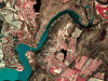
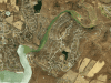
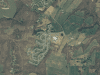
Coldstream, North Shore, and Nightingale
https://maps.lakelinganore.org/wp-content/uploads/slideshow-gallery/Coldstream-NS-Nightingale-scaled.jpgThe following screenshots are from Frederick County's Geographic Information Systems (GIS) Aerial Report from 1973 to 2017.

-
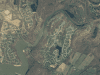
Coldstream, North Shore, and Nightingale 1973
https://maps.lakelinganore.org/wp-content/uploads/2020/03/1973-3.pngScreenshots are from Frederick County's Geographic Information Systems (GIS) Aerial Report.
-
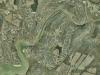
Coldstream, North Shore, and Nightingale 1988
https://maps.lakelinganore.org/wp-content/uploads/2020/03/1988-2.pngScreenshots are from Frederick County's Geographic Information Systems (GIS) Aerial Report.
-
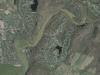
Coldstream, North Shore, and Nightingale 1993
https://maps.lakelinganore.org/wp-content/uploads/2020/03/1993-3.pngScreenshots are from Frederick County's Geographic Information Systems (GIS) Aerial Report.

-
Coldstream, North Shore, and Nightingale 2000
https://maps.lakelinganore.org/wp-content/uploads/2020/03/2000-3.pngScreenshots are from Frederick County's Geographic Information Systems (GIS) Aerial Report.

-
Coldstream, North Shore, and Nightingale 2005
https://maps.lakelinganore.org/wp-content/uploads/2020/03/2005-3.pngScreenshots are from Frederick County's Geographic Information Systems (GIS) Aerial Report.

-
Coldstream, North Shore, and Nightingale 2007
https://maps.lakelinganore.org/wp-content/uploads/2020/04/Coldstream-2007.pngScreenshots are from Frederick County's Geographic Information Systems (GIS) Aerial Report.

-
Coldstream, North Shore, and Nightingale 2011
https://maps.lakelinganore.org/wp-content/uploads/2020/03/2011-4.pngScreenshots are from Frederick County's Geographic Information Systems (GIS) Aerial Report.
-
Coldstream, North Shore, and Nightingale 2014
https://maps.lakelinganore.org/wp-content/uploads/2020/03/2014-3.pngScreenshots are from Frederick County's Geographic Information Systems (GIS) Aerial Report.

-
Coldstream, North Shore, and Nightingale 2017
https://maps.lakelinganore.org/wp-content/uploads/2020/04/Coldstream-2017.pngScreenshots are from Frederick County's Geographic Information Systems (GIS) Aerial Report.

-
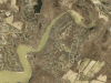
Meadows
https://maps.lakelinganore.org/wp-content/uploads/slideshow-gallery/Meadows-scaled.jpgThe following screenshots are from Frederick County's Geographic Information Systems (GIS) Aerial Report from 1973 to 2017.

-
Meadows 1973
https://maps.lakelinganore.org/wp-content/uploads/2020/03/1973-4.pngScreenshots are from Frederick County's Geographic Information Systems (GIS) Aerial Report.
-
Meadows 1988
https://maps.lakelinganore.org/wp-content/uploads/2020/03/1988-3.pngScreenshots are from Frederick County's Geographic Information Systems (GIS) Aerial Report.
-
Meadows 1993
https://maps.lakelinganore.org/wp-content/uploads/2020/03/1993-4.pngScreenshots are from Frederick County's Geographic Information Systems (GIS) Aerial Report.
-
Meadows 2000
https://maps.lakelinganore.org/wp-content/uploads/2020/03/2000-4.pngScreenshots are from Frederick County's Geographic Information Systems (GIS) Aerial Report.
-
Meadows 2005
https://maps.lakelinganore.org/wp-content/uploads/2020/03/2005-4.pngScreenshots are from Frederick County's Geographic Information Systems (GIS) Aerial Report.

-
Meadows 2007
https://maps.lakelinganore.org/wp-content/uploads/2020/03/2007-3.pngScreenshots are from Frederick County's Geographic Information Systems (GIS) Aerial Report.
-
Meadows 2011
https://maps.lakelinganore.org/wp-content/uploads/2020/03/2011-5.pngScreenshots are from Frederick County's Geographic Information Systems (GIS) Aerial Report.
-
Meadows 2014
https://maps.lakelinganore.org/wp-content/uploads/2020/03/2014-4.pngScreenshots are from Frederick County's Geographic Information Systems (GIS) Aerial Report.
-
Meadows 2017
https://maps.lakelinganore.org/wp-content/uploads/2020/03/2017-2.pngScreenshots are from Frederick County's Geographic Information Systems (GIS) Aerial Report.

-
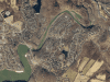
Summerfield
https://maps.lakelinganore.org/wp-content/uploads/slideshow-gallery/Summerfield-scaled.jpgThe following screenshots are from Frederick County's Geographic Information Systems (GIS) Aerial Report from 1973 to 2017.

-
Summerfield 1973
https://maps.lakelinganore.org/wp-content/uploads/2020/04/1973-2.pngScreenshots are from Frederick County's Geographic Information Systems (GIS) Aerial Report.

-
Summerfield 1988
https://maps.lakelinganore.org/wp-content/uploads/2020/04/1988-2.pngScreenshots are from Frederick County's Geographic Information Systems (GIS) Aerial Report.
-
Summerfield 1993
https://maps.lakelinganore.org/wp-content/uploads/2020/04/1993-3.pngScreenshots are from Frederick County's Geographic Information Systems (GIS) Aerial Report.

-
Summerfield 2000
https://maps.lakelinganore.org/wp-content/uploads/2020/04/2000-2.pngScreenshots are from Frederick County's Geographic Information Systems (GIS) Aerial Report.
-
Summerfield 2005
https://maps.lakelinganore.org/wp-content/uploads/2020/04/2005-2.pngScreenshots are from Frederick County's Geographic Information Systems (GIS) Aerial Report.
-
Summerfield 2007
https://maps.lakelinganore.org/wp-content/uploads/2020/04/2007-2.pngScreenshots are from Frederick County's Geographic Information Systems (GIS) Aerial Report.
-
Summerfield 2011
https://maps.lakelinganore.org/wp-content/uploads/2020/04/2011-2.pngScreenshots are from Frederick County's Geographic Information Systems (GIS) Aerial Report.
-
Summerfield 2014
https://maps.lakelinganore.org/wp-content/uploads/2020/04/2014-2.pngScreenshots are from Frederick County's Geographic Information Systems (GIS) Aerial Report.
-
Summerfield 2017
https://maps.lakelinganore.org/wp-content/uploads/2020/04/2017-2.pngScreenshots are from Frederick County's Geographic Information Systems (GIS) Aerial Report.
-
West Winds and Woodlands Preserve
https://maps.lakelinganore.org/wp-content/uploads/slideshow-gallery/WW-and-WP-scaled.jpgThe following screenshots are from Frederick County's Geographic Information Systems (GIS) Aerial Report from 1973 to 2017.

-
West Winds and Woodlands Preserve 1973
https://maps.lakelinganore.org/wp-content/uploads/2020/04/1973-1.pngScreenshots are from Frederick County's Geographic Information Systems (GIS) Aerial Report.

-
West Winds and Woodlands Preserve 1988
https://maps.lakelinganore.org/wp-content/uploads/2020/04/1988-1.pngScreenshots are from Frederick County's Geographic Information Systems (GIS) Aerial Report.

-
West Winds and Woodlands Preserve 1993
https://maps.lakelinganore.org/wp-content/uploads/2020/04/1993-2.pngScreenshots are from Frederick County's Geographic Information Systems (GIS) Aerial Report.

-
West Winds and Woodlands Preserve 2000
https://maps.lakelinganore.org/wp-content/uploads/2020/04/2000-1.pngScreenshots are from Frederick County's Geographic Information Systems (GIS) Aerial Report.

-
West Winds and Woodlands Preserve 2005
https://maps.lakelinganore.org/wp-content/uploads/2020/04/2005-1.pngScreenshots are from Frederick County's Geographic Information Systems (GIS) Aerial Report.

-
West Winds and Woodlands Preserve 2007
https://maps.lakelinganore.org/wp-content/uploads/2020/04/2007-1.pngScreenshots are from Frederick County's Geographic Information Systems (GIS) Aerial Report.
-
West Winds and Woodlands Preserve 2011
https://maps.lakelinganore.org/wp-content/uploads/2020/04/2011-1.pngScreenshots are from Frederick County's Geographic Information Systems (GIS) Aerial Report.
-
West Winds and Woodlands Preserve 2014
https://maps.lakelinganore.org/wp-content/uploads/2020/04/2014-1.pngScreenshots are from Frederick County's Geographic Information Systems (GIS) Aerial Report.
-
West Winds and Woodlands Preserve 2017
https://maps.lakelinganore.org/wp-content/uploads/2020/04/2017-1.pngScreenshots are from Frederick County's Geographic Information Systems (GIS) Aerial Report.
-
Audubon North, Audubon North Terrace, and Audubon Condos
https://maps.lakelinganore.org/wp-content/uploads/slideshow-gallery/AN-ANT-AC-scaled.jpgThe following screenshots are from Frederick County's Geographic Information Systems (GIS) Aerial Report from 1973 to 2017.

-
Audubon North, Audubon North Terrace, and Audubon Condos 1973
https://maps.lakelinganore.org/wp-content/uploads/2020/03/1973-1.pngScreenshots are from Frederick County's Geographic Information Systems (GIS) Aerial Report.
-
Audubon North, Audubon North Terrace, and Audubon Condos 1988
https://maps.lakelinganore.org/wp-content/uploads/2020/03/1988.pngScreenshots are from Frederick County's Geographic Information Systems (GIS) Aerial Report.
-
Audubon North, Audubon North Terrace, and Audubon Condos 1993
https://maps.lakelinganore.org/wp-content/uploads/2020/03/1993-1.pngScreenshots are from Frederick County's Geographic Information Systems (GIS) Aerial Report.
-
Audubon North, Audubon North Terrace, and Audubon Condos 2000
https://maps.lakelinganore.org/wp-content/uploads/2020/03/2000-1.pngScreenshots are from Frederick County's Geographic Information Systems (GIS) Aerial Report.
-
Audubon North, Audubon North Terrace, and Audubon Condos 2005
https://maps.lakelinganore.org/wp-content/uploads/2020/03/2005-1.pngScreenshots are from Frederick County's Geographic Information Systems (GIS) Aerial Report.

-
Audubon North, Audubon North Terrace, and Audubon Condos 2007
https://maps.lakelinganore.org/wp-content/uploads/2020/03/2007-1.pngScreenshots are from Frederick County's Geographic Information Systems (GIS) Aerial Report.
-
Audubon North, Audubon North Terrace, and Audubon Condos 2011
https://maps.lakelinganore.org/wp-content/uploads/2020/03/2011-1.pngScreenshots are from Frederick County's Geographic Information Systems (GIS) Aerial Report.

-
Audubon North, Audubon North Terrace, and Audubon Condos 2014
https://maps.lakelinganore.org/wp-content/uploads/2020/03/2014-1.pngScreenshots are from Frederick County's Geographic Information Systems (GIS) Aerial Report.
-
Woodridge and Aspen North
https://maps.lakelinganore.org/wp-content/uploads/slideshow-gallery/Woodridge-and-Aspen-NOrth-scaled.jpgThe following screenshots are from Frederick County's Geographic Information Systems (GIS) Aerial Report from 1973 to 2017.

-
Woodridge and Aspen North 1973
https://maps.lakelinganore.org/wp-content/uploads/2020/04/1973.pngScreenshots are from Frederick County's Geographic Information Systems (GIS) Aerial Report.
-
Woodridge and Aspen North 1988
https://maps.lakelinganore.org/wp-content/uploads/2020/04/1988.pngScreenshots are from Frederick County's Geographic Information Systems (GIS) Aerial Report.
-
Woodridge and Aspen North 1993
https://maps.lakelinganore.org/wp-content/uploads/2020/04/1993-1.pngScreenshots are from Frederick County's Geographic Information Systems (GIS) Aerial Report.

-
Woodridge and Aspen North 2000
https://maps.lakelinganore.org/wp-content/uploads/2020/04/2000.pngScreenshots are from Frederick County's Geographic Information Systems (GIS) Aerial Report.
-
Woodridge and Aspen North 2005
https://maps.lakelinganore.org/wp-content/uploads/2020/04/2005.pngScreenshots are from Frederick County's Geographic Information Systems (GIS) Aerial Report.

-
Woodridge and Aspen North 2007
https://maps.lakelinganore.org/wp-content/uploads/2020/04/2007.pngScreenshots are from Frederick County's Geographic Information Systems (GIS) Aerial Report.

-
Woodridge and Aspen North 2011
https://maps.lakelinganore.org/wp-content/uploads/2020/04/2011.pngScreenshots are from Frederick County's Geographic Information Systems (GIS) Aerial Report.

-
Woodridge and Aspen North 2014
https://maps.lakelinganore.org/wp-content/uploads/2020/04/2014.pngScreenshots are from Frederick County's Geographic Information Systems (GIS) Aerial Report.
-
Woodridge and Aspen North 2017
https://maps.lakelinganore.org/wp-content/uploads/2020/04/2017.pngScreenshots are from Frederick County's Geographic Information Systems (GIS) Aerial Report.

-
Oakdale and Linganore Garden Condos
https://maps.lakelinganore.org/wp-content/uploads/slideshow-gallery/Oakdale-and-LGC-scaled.jpgThe following screenshots are from Frederick County's Geographic Information Systems (GIS) Aerial Report from 1973 to 2017.

-
Oakdale and Linganore Garden Condos 1973
https://maps.lakelinganore.org/wp-content/uploads/2020/04/Oakdale-1973.pngScreenshots are from Frederick County's Geographic Information Systems (GIS) Aerial Report.
-
Oakdale and Linganore Garden Condos 1988
https://maps.lakelinganore.org/wp-content/uploads/2020/04/Oakdale-1988.pngScreenshots are from Frederick County's Geographic Information Systems (GIS) Aerial Report.
-
Oakdale and Linganore Garden Condos 1993
https://maps.lakelinganore.org/wp-content/uploads/2020/04/Oakdale-1993.pngScreenshots are from Frederick County's Geographic Information Systems (GIS) Aerial Report.

-
Oakdale and Linganore Garden Condos 2000
https://maps.lakelinganore.org/wp-content/uploads/2020/04/Oakdale-2000.pngScreenshots are from Frederick County's Geographic Information Systems (GIS) Aerial Report.
-
Oakdale and Linganore Garden Condos 2005
https://maps.lakelinganore.org/wp-content/uploads/2020/04/Oakdale-2005.pngScreenshots are from Frederick County's Geographic Information Systems (GIS) Aerial Report.

-
Oakdale and Linganore Garden Condos 2007
https://maps.lakelinganore.org/wp-content/uploads/2020/04/Oakdale-2007.pngScreenshots are from Frederick County's Geographic Information Systems (GIS) Aerial Report.
-
Oakdale and Linganore Garden Condos 2011
https://maps.lakelinganore.org/wp-content/uploads/2020/04/Oakdale-2011.pngScreenshots are from Frederick County's Geographic Information Systems (GIS) Aerial Report.
-
Oakdale and Linganore Garden Condos 2014
https://maps.lakelinganore.org/wp-content/uploads/2020/04/Oakdale-2014.pngScreenshots are from Frederick County's Geographic Information Systems (GIS) Aerial Report.
-
Oakdale and Linganore Garden Condos 2017
https://maps.lakelinganore.org/wp-content/uploads/2020/04/Oakdale-2017.pngScreenshots are from Frederick County's Geographic Information Systems (GIS) Aerial Report.